
THANKS FOR BEING THE BEST GEOGRAPHY CLASS :) You are such great students, you will all have fantastic futures .good luck in the exams, have a great summer... enjoy yourselves xx
15th June: Quick Revision Weather and Climate - these were the key questions today:
Weather
Briefly describe (or sketch) the water cycle, particularly including formation of precipitation
3 main types of rainfall?
Sketch a low pressure system and say what each element is
What is the typical sequence of weather (ppt, wind speed and direction, cloud cover, temps, etc.) as a depression passes?
Describe the types of conditions associated with anticyclones in summer and winter.
Climate
Look at the five major climate graphs we studied and test each other, describing the characteristics (max, min temps, temp range, ppt totals, etc.)
Describe the following for monsoon climate, and then do the same for cold climate:
Climate graph:
Typical weather:
Causes of this type of climate:
Natural vegetation and how it is adapted to this type of climate:
Human activities and how they are adapted:

13th June: Revision lesson. Exam:
Section A weather and climate 50 marks Analysing documents and answering longer questions using examples, knowledge we have learned in lessons.
Section B Urban Studies 50 marks Analysing documents and answering longer questions. Also 30 marks on an extended writing task - make sure you leave enough time, or even do it first.
Here are the revision questions:
Urban Studies Revision
Define the following:
CBD
Site and Situation
Function of a settlement
Settlement hierarchy
Sphere of influence of a shop/business or settlement Briefly summarise the different urban models we looked at and what type of cities (LEDCs, MEDCs) fit into these patterns, giving reasons.
Challenges facing urban areas
Why do people want to visit out of town shopping centres?
What effect is this having on the city centre?
How are shops and businesses adapting?
What is the ‘dualisation’ of Brussels and what is causing it? What exactly is the problem? How does it relate to the urban models you have studied?
What are suggested and real solutions to this problem?
What are the typical zones found in a British city? (describe housing, social character and appearance on a map)
How are cities growing in LEDCs? Give examples
What are ‘megacities’?
What kinds of problems is this massive urban growth in LEDCs causing? (think about social, economic, environmental, and use case studies/examples we have looked at)
How are some of these problems in LEDCs being faced by local communities or governments? (Choose two problems and write about causes, consequences and solutions)
Why is there such division between wealthy and poor in LEDCs? Give examples
MEDCs: Urban regeneration – London 2012 Olympics
What problems were being faced in certain parts of the city of London?
How did the redevelopment aim to help?
In what ways was it successful?
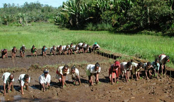 Intensive Rice Cultivation
8th June: For Cold Climate :
We talked about coniferous forests and how they are adapted to the cold climate (p. 235), and the Tundra and its characteristics. We also mentioned the effects on people, for example nomadic herding of reindeer in Siberia or the hunting of the innuit peoples. Here are some links to relevant videos:
Innuit/Eskimo Culture
https://www.youtube.com/watch?v=N5ooFU5HosU
Impact global warming on Innuit\
https://www.youtube.com/watch?v=3JogbCjTDBs
Nomadic reindeer in Siberia/ The Taiga
https://www.youtube.com/watch?v=HFWj0jEaJ5w
For Monsoon Climate
The formation of high pressure in the winter and low pressure in the summer over the Indian sub-continent causes the monsoon climate (p. 214). This can cause flooding but also has great benefits for farmers who have developed intensive rice cultivation in these areas (p. 112).
Monsoon
(planet earth BBC)
https://www.youtube.com/watch?v=M0lTfJDiZsw
Monsoon floods
https://www.youtube.com/watch?v=Ov_5WeR4DcY
HOMEWORK : REVISION
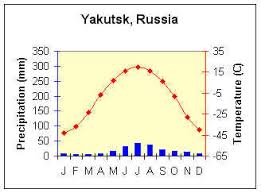
6th June: We looked at Climate graphs for the 5 major climates: Equatorial, Tropical Continental, Monsoon, Hot Desert and Cold climate (pages 212 to 215) and the characteristics of each. Then we read about the cold climate (p. 215).
Homework: For Cold Climate :
How does the climate affect the vegetation, and the biome (flora and fauna) ?
How does the climate affect human activities (eg. Farming) in these areas?
Research using books/internet for homework for Thursday, a summary of what you found out
Homework: For Cold Climate :
How does the climate affect the vegetation, and the biome (flora and fauna) ?
How does the climate affect human activities (eg. Farming) in these areas?
Research using books/internet for homework for Thursday, a summary of what you found out

1st June: Revision for exams – It is the two units we have done in the second part of the year ie. ‘Urban Studies’ and ‘Weather and Climate’, although you may use your knowledge of earlier units, including year 4. If you need extra help in revision, don’t hesitate to talk to me and we can arrange an appointment (prob. a lunchtime) to give extra help.
Homework for next time: Complete sheets with the other two factors affecting temperature (we covered latitude, distance from sea and altitude in the lesson) using p. 211 of the text book and shade the map on your sheets with the climates on p. 211.
Homework for next time: Complete sheets with the other two factors affecting temperature (we covered latitude, distance from sea and altitude in the lesson) using p. 211 of the text book and shade the map on your sheets with the climates on p. 211.

30th May: We discussed today's weather pressure chart in relation to depressions and anti-cyclones, and revised some of the principles about reading weather maps in terms of:
Wind speed and direction
pressure system
precipitation
temperature.
Homework: Read carefully about depressions and anticyclones (p.204 to 206) for a test next lesson.
Wind speed and direction
pressure system
precipitation
temperature.
Homework: Read carefully about depressions and anticyclones (p.204 to 206) for a test next lesson.
 Cross section of a depression
18th May: Synoptic symbols are used by professional weather organisations in making weather maps, for example: metoffice.gov.uk
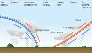
We visualised depressions in both plan view and cross section, and described the weather progression which happens as a typical depression passes over - starting with high cirrus clouds, then the cloud base lowers and we get drizzly rain which increases in strength as the warm front passes, then temperatures rise and skies clear in the warm sector, followed by heavy rain and cumulonimbus clouds as the faster moving cold front passes. (see animation)
Your homework for the next lesson is to finish both sides of the A3 worksheet which I gave you in the lesson.
 What type of cloud is this?
11th May: We looked at:
Revising the types of rain and pressure system
How to measure weather (anemometer, barometer, rain gauge, etc.) including a home weather station to upload to user generated weather prediction applications
The Beaufort scale for measuring effects of wind speeds
Types of clouds
Revising the types of rain and pressure system
How to measure weather (anemometer, barometer, rain gauge, etc.) including a home weather station to upload to user generated weather prediction applications
The Beaufort scale for measuring effects of wind speeds
Types of clouds
 The 'star' junction of the 'Arc du Triomphe'
Write a report on the field trip to Paris
Due May 18th:
Include:
Analysis of the Urban Geography of Paris including zones, land use, types of shops and services (Gare du Nord, Champs-Elysees, Ile de la Cite, Eiffel Tower), the contrast between the different areas. How does this relate to the work we did in class?
A statistical analysis including at least two charts/graphs of the results of your surveys together with a written evaluation/conclusion of your research. Were your methods good/representative? How could you have improved the accuracy of results/surveys? Were the questions you asked appropriate? What else could you have done?
Annotated diagrams or photos (annotations are labels with explanation) of the locations we studied or sketched.
Reference to historic urban change/renewal and how this influences the present day city.
Marked on:
Complexity and accuracy of content
Use of geographical expression
Quality of presentation
Originality
Use of sources and own words
Comments:
DO NOT COPY AND PASTE TEXT (unless it’s a sourced quote)
This is individual work and an individual report
Approx.. length 4 to 5 pages

INFORMATION ABOUT TRIP TO PARIS NEXT TUESDAY:
We are leaving gare du midi on the Thalys at 08:13 and will return there at 19.17. Start gathering at the Thalys entrance in Gare du Midi from 07:50. Students to be collected there at 19:17 sharp. I am not taking responsibility for them when they leave the area of the THALYS trains – please let us know if students are making their own way home. There will also be five teachers on the field study.
If you have any questions re the trip please get back to me.
To Bring: Writing materials clipboard/notebook to rest on/warm clothes, be prepared for rain!/walking shoes/packed lunch if you want although we will have chance to buy lunch. Bring some money for snacks, etc or food to eat. Always stay in groups of three at least.
Make 2 questionnaires – copy 10 sets of each
Groups of three
8 to 10 questions to ask passers by/pedestrians/tourists
One is for the Eiffel Tower, the other is for the Champs Elysees
Mixture of open and closed questions to get information about where they come from, how long/where they are staying, what they think about various aspects of Paris (attractions, price, satisfaction, shopping), reason for trip, etc. etc. We had some good ideas for questions in today’s lesson.
For the Trip next week:
Two questionnaires, typed, one for the Champs-Elysees and the other for the Eiffel Tower. 10 COPIES OF EACH. Also make sure you have the translations noted down about how to ask the questions in French.
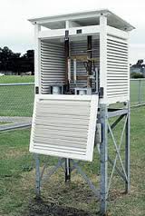 This is a STEVENSON SCREEN used to house weather recording instruments
31st March: The water cycle and temperature
We reviewed the water cycle and the stores, transfers and processes. Here is a great video to help you in your revision of this:
https://www.youtube.com/watch?v=al-do-HGuIk
or this shorter one from bbc bitesize:
https://www.youtube.com/watch?v=NKInYFOrtmc
Then we outlined high and low pressure and their characteristics:
High - stable - descending air - descends clockwise - clear conditions - cold in winter, hot in summer
Low - unstable - rising air, cools, condenses, forms clouds and precipitation - ascends anti clockwise - mild conditions with cloud cover
After that, we talked about temperature and how it is measured
Then we made some notes about the factors affecting temperature - altitude, latitude, etc.
For Homework (next Tuesday 4th April): Complete the sheet with notes for each factor on p. 201 which affects temperature – latitude, distance from sea, altitude, prevailing winds, ocean currents.

Weather and Climate (29th March)
Use pages 200 - 201 and the internet:
Use pages 200 - 201 and the internet:
- What is the difference between weather and climate?
- What is our type of climate?
- What types of air masses influence our climate?
- What is atmospheric pressure and how is it measured?

23rd March: We discussed the problem of the juxtaposition of rich and poor within LEDC cities like Sao Paulo, Jakarta and Kolkatta, and more about the separation of the parts of Brussels.
Homework for next Tuesday 28th: read pages 60 and 61 and do question no. 2 on p. 75 (written answers) which I will collect next lesson.
It is about urban regeneration, the Olympics 2012 in London. The text is a little out of date because it was written before the Olympics, but still has much useful information about how the area changed.
 Traffic and air pollution in Hanoi, Vietnam. You can see many locals wearing masks.
Urban Studies : Problems and Solutions
HOMEWORK: Last lesson we looked at Kolkata and Sao Paulo – p. 82 to 85. Make sure you have good notes about both – problems (housing, overcrowding, facilities, amenities, hygiene, etc.) and solutions (self-help schemes, renovating, improving shanties, rebuilding).
Today: Traffic and air pollution
Over the past 50 years the amount of traffic in cities has steadily increased, both in LEDCs and MEDCs. We wrote notes on the following:
Why has the traffic increased (give 3 or 4 reasons)?
What are the negative effects? (separate into environmental, economic and social)
What solutions have been introduced to solve the traffic problem? Think of examples from cities you know.
Also, read pages 66 to 67 about transport in urban areas.
We looked at Kolkata and thought about how the air pollution/traffic there compares with MEDCs, and briefly about what China did to reduce the air pollution in Beijing before the 2008 Olympics.
16th March: We compared and contrasted Sao Paulo (p. 82 to 83) and Kolcata (p. 84 to 85).
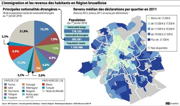
14th March: A problem faced by cities in developing countries: Immigration and ghettoisation in Brussels. We talked about the dualisation of Brussels, the split between the more wealthy South East and the poorer Northwest, along wealth, ethnic origin and religious lines. This causes a lot of problems for the city and the various groups involved. We also discussed possible solutions within the local community or national government.
For Thursday, write down five points that could be done or are being done in order to prevent the dualisation of Brussels. For each point, explain your reasons about how and why it would help.
Approx. 200 to 300 words
For Thursday, write down five points that could be done or are being done in order to prevent the dualisation of Brussels. For each point, explain your reasons about how and why it would help.
Approx. 200 to 300 words
 A favela in Rio, Brazil (actually the one where fast and furious five was shot), you can see the contrast with the high class apartments closer to the CBD
9th March: Urban growth in LEDCs. We talked about the reasons for the massive urbanisation taking place in developing countries, causing shanty towns and poor conditions on the edges of many developing cities. We also talked about how urban models for LEDC cities are different to those for MEDCs, because for example the high class housing is close to the city centre and the shanty towns are accumulating on the periphery of the city. Also is many tropical South East Asian cities eg. Kuala Lumpur, Singapore, the multiple nucleii model is much more appropriate at clustering occurrs around air conditioned shopping models which serve as centres for food, shopping and entertainment. Homework revise pages 80 to 81 for a short test next lesson
Urban Growth in Developing countries (28th Feb)
Read pages 78 to 79 and answer the following:
Describe the patterns on figure 5.2 p. 78 which shows world urban population. What patterns do you notice?
What change has there been in location of ‘million cities’? Use 5.4 to help you.
What is a ‘megacity’?
What is an agglomeration and why is it difficult to measure their populations?
Where are the fastest growing cities now? Give examples.
Why are people in developing countries going to the cities (rural urban migration)
Homework for Thursday: imagine a typical village in a developing country. List the things making people want to leave (push factors), then list the factors attracting people to the city (pull factors)
 A lowry painting from the early 20th century showing crowded streets with industry and terraced housing nearby
Thursday 16th February: Pages 46, 47 but particularly 48 to 49 and the different zones in a British city:
Old Inner City: Redeveloped Inner City: Suburbia: Outer City Council Estate
We looked at the characteristics of land use, type and age of housing, road pattern and appearence on a map, housing tenure, socio economic class of people living there, etc. Exercise 7 on p. 56 is to fill the table with information about Old inner city area and suburbia.
 Traditional terraced housing in the UK
Tuesday 14th February: We looked at pages 44 and 45, zones in British cities.
Homework for Thursday: Which model do you think is most relevant to the city of Brussels from the different urban zoning models which we have studied in class? Write at least 200 words to state and support your conclusions to hand in with your map. Use paragraphs in your answer.
Homework for Thursday: Which model do you think is most relevant to the city of Brussels from the different urban zoning models which we have studied in class? Write at least 200 words to state and support your conclusions to hand in with your map. Use paragraphs in your answer.

Urban zoning models applied to the city of Brussels
Shade on the map of Brussels, using a key (on a different sheet of paper) and different colours (eg. One colour for CBD areas, another for low class residential areas, another for light industry, etc.). Use a map and shade with coloured pencils or colours which are not too heavy so you can still see the streets underneath. Sorry the maps I gave you were not the best quality so it would be great if you could find a better map or a different way of doing it eg. Import into a sketch/paint programme on your tablet and add colours that way. Borders between areas don’t have to be heavy and definite, because that is not the way it works in real life! (for example if you walk from the Grand Place to Rue Blaes low class residential, it doesn’t suddenly change, but it is more gradual). I will collect these maps in on the 14th Feb. so make a good job of it and I will give marks for presentation and accuracy. These are the areas to shade:
The inner ring (petit ceinture) which follows the old city walls.
The canal
The main railways (SW from Gare du Midi and NE from Gare du Nord)
Shopping centre (Rue Nueve)
Old centre (Grand Place)
Financial centre (Quartier Nord)
Park and royal palace
Light industry – along canal and railways, to Vilvoorde (NE) and Vorst (SW)
Royal palace Laeken
European Quarter
Low class residential – rue Blaes, quai du commerce, Schaerbeek, Molenbeek, Anderlecht, Gare du Midi/Saint-Gilles.
Medium class residential eg. Woluwe Saint-Pierre, Auderghem, Uccle, Watermael Boitsfort.
High class residential eg. South Uccle, Saint Job, Overijse, Tervuren (you may have to put pointers to the area outside your map).

7th Feb: More about out of town shopping centres - an article about which you wrote the advantages and disadvantages from, in a short piece of writing, and also an article from the Guardian which described how out of town shopping centres are beginning to decline. We discussed a little about how our urban centres may change in the future.
 The Aupark Centre, Bratislava
Feb 2nd: We talked about the multi-nucleii model and about how outlying business districts and out of town shopping centres are drawing consumers from the traditional CBD in the centre of town. Centres which are out of town have more benefits for the consumer, and also for businesses and services. We made a list of these in the lesson. We came up with examples of our own, in Brussels (eg. Woluwe Mall), in Bratislava (eg. Aupark centre among others), and in the UK (Trafford Centre Manchester). We will talk about this more next lesson. Also about Brussels and which urban growth model you think best fits.

31st Jan: More details about the two urban models and the types of associated housing. Terraced, semi-detached and detached. We talked about how land-use, height of buildings, amount of greenery, amount of traffic and pedestrians, land price, etc. change with distance from the city centre or within the different zones of the model. We talked about Charleroi and the river Sambre as an example of the Hoyt model where the industrial sector of heavy industry and its associated working class terraced housing grew up along the river. Other transport routes such as roads and railways may also influence the growth of a city in such a way.
For Homework (Tue 5th): Research and write about the following in your own words on the sheet:
A multiple nuclei model
A combination model
For Homework (Tue 5th): Research and write about the following in your own words on the sheet:
A multiple nuclei model
A combination model
26th Jan: we talked about different models of urban growth. Homework: Draw a diagram of the Burgess and Hoyt model together with labels and explanations on the sheet.
 The CBD (Central Business District) of Los Angeles
24th January: We discussed next years options, and I gave you some sheets with information about 4 lesson Geography.
Homework: Complete the first five definitions on the sheet in your own words from researching in your book/internet.
They are:
Urban Hierarchy
Sphere of Influence
Range
Threshold population
CBD
Homework: Complete the first five definitions on the sheet in your own words from researching in your book/internet.
They are:
Urban Hierarchy
Sphere of Influence
Range
Threshold population
CBD
We talked about a settlement hierarchy based on the number of services rather than population.
We made a table like the one in fig.3.13 p. 38.
For next lesson (Tue 24th), complete each section of the table with some of your ideas, and we will discuss in groups next lesson.
We made a table like the one in fig.3.13 p. 38.
For next lesson (Tue 24th), complete each section of the table with some of your ideas, and we will discuss in groups next lesson.
17th Jan:
We talked about settlement names (Chester, ...ham, .....by, ...ton, etc.)
Settlement patterns, functions of a settlement and settlement hierarchy (p. 36 to 39)
Homework: Complete the notes and revise
We talked about settlement names (Chester, ...ham, .....by, ...ton, etc.)
Settlement patterns, functions of a settlement and settlement hierarchy (p. 36 to 39)
Homework: Complete the notes and revise
 Ile de la cité, Paris, the original settlement site.
The new unit is : URBAN STUDIES
We started by looking at site and situation, covering p. 34 and 35 of the text book.
SITE - local factors governing why the site was first chosen as a settlement location. eg. water supply, defence, etc.
SITUATION - surrounding factors governing why the site grew into a larger settlement eg. transport links, trade links, etc.
1st December: We looked at malnutrition, and the terms on p. 110 of the textbook. We analysed the world map of DES, looking at world patterns of farming and climate from the other world maps on p. 97 (farming) and p. 210 (world climate)
Homework for Thursday (1st December) complete the questions on the sheet – watch the two videos, read the article and page on the text book in order to answer them well.
Here are the questions from the sheet:
http://www.rspo.org/about/sustainable-palm-oil
What are the four requirements for sustainable palm oil?
http://www.geographypods.com/palm-oil--me.html and online article from ‘transport environment’
https://www.transportenvironment.org/news/dramatic-deforestation-highlights-eu-%E2%80%98folly%E2%80%99-biofuels
What is palm oil based biodiesel an alternative to?
Why is the demand for palm oil based biodiesel increasing?
What is ironic about the connection?
How is the demand for biodiesel driving illegal logging?
Why is the Indonesian government allowing logging?
Revision from last year: What effects is the deforestation of rainforests having on the local and global environment?
p. 103 text book:
What advantages does palm oil have over rubber as a plantation crop?
What are the consequences for food production in Malaysia?
 Palm oil plantations are rapidly encroaching on virgin rainforest in South East Asia
24th November: Palm Oil – globalisation of a food crop and associated issues
Homework for next Tuesday: finish the activities on the sheet, except activity 9.
Instructions:
Search on google: ‘palm oil geography’
Top of search should be ‘palm oil and me’ geography pods
Click on ‘guardian interactive resource’ and start the worksheet (the worksheet can be downloaded, it is 'Palm Oil Work Booklet')
22nd November: We compared two types of farming, Extensive commercial farming of cereals in East Anglia and extensive farming of sheep in the hills of the Lake District, using p. 100 and 101 of the text book. We completed a table comparing and contrasting the two (finish for homework)
Main homework to be collected on Thursday 24th:
How are the different types of farming in the UK related to the rainfall and relief?
Using the three maps of the United Kingdom:
Describe the distribution using figures from the maps (3)
Explain the reasons for the distribution (7)
Note: In the UK climate, weather systems (depressions) bring rain from the West. You could look at p. 202 to help you.
On Thursday’s lesson, go to A31 computer room.
Also homework is REVISION
 Upland areas in the Lake District have high rainfall, undulating relief and thin rocky soils - sheep farming is the best option
17th November:
We talked about how a farmer decides which crops to grow, taking into consideration various factors such as climate, relief, proximity to markets, etc. (p. 98)
Homework for next Tuesday 22nd:
Complete the table on the sheet.
Research/study the mountain ranges and cities of the UK. We will look at the maps next lesson
19th November: We did pages 96 to 97 of the textbook and created a table for the map on p. 97. Homework for Thursday:
Complete the table on p. 97. Work with your partner so that he/she chooses three to research and you have three, to swap information on Thursday’s lesson.
Complete the table on p. 97. Work with your partner so that he/she chooses three to research and you have three, to swap information on Thursday’s lesson.
Homework for 15th Nov: Research and complete the sheet about different types of farming for next lesson, so you have all the boxes completed with lots of information.
 battery farming of chickens
8th November:
We started talking about different types of farming in the next unit which we are studying, called 'Feeding the World'. We defined and gave details of the following terms;
Arable, pastoral, mixed, cattle, cereals, dairy, subsistence, commercial, plantations, monoculture, inputs, processes, outputs, extensive, intensive, fertilizers, pesticides, pasture, etc. A lot of these terms you knew already from your 3rd year work with Mr. Newman.
We looked at several different types of farming and the inputs, processes and outputs associated with them.
 Valley of Lauterbrunnen, Switzerland. A glacial trough, truncated spurs, hanging valley and waterfall
27th October: In this lesson we talked about features of glacial erosion and explained the following:
We will not do features of glacial deposition (p. 319)
- formation of a glacier and a corrie
- a glacial trough or U shaped valley
- pyrimidal peak
- an arete
- ribbon lakes and misfit streams
- truncated spurs and hanging valleys
We will not do features of glacial deposition (p. 319)
 Aletsch Glacier Switzerland – nasa.gov
25th October: We started on glaciers and looking at how the processes happening in glaciers are similar/different to those going on in rivers. There are inputs, stores, flows and outputs just like a river system. In addition, erosion happens, but by abrasion and plucking. Transportation also occurs as the glaciers carry the load, or ‘morraine’, and there is deposition too in the zone of ablation where terminal moraine is accumulated. Read more on p. 316 of the text book.

18th October: We talked about waterfalls, levees and deltas. Homework to read pages 286 to 289 about flooding in LEDCs and MEDCs
On the left you can see the waterfall at Ingleton, in Yorkshire, showing the classic features of more restistant and less resistant rock, an overhang, a gorge, plunge pool and fragments of the overhang which have fallen around the plunge pool
On the left you can see the waterfall at Ingleton, in Yorkshire, showing the classic features of more restistant and less resistant rock, an overhang, a gorge, plunge pool and fragments of the overhang which have fallen around the plunge pool
 Diagram to show the long profile of a typical river
13th October: We discussed the features and characteristics of a typical river in its three stages of the long profile, the upper, middle and lower course, noting the features on the diagram I gave you (shown on the left). We won't have enough time in lessons to cover all the material you need to know, so you need to read the pages carefully for homework and know them to describe and explain next lesson:
Homework for Tuesday :
Review the 3 stages of a river, p. 282 to 285.
Prepare for next lesson to draw diagrams and explain:
Homework for Tuesday :
Review the 3 stages of a river, p. 282 to 285.
Prepare for next lesson to draw diagrams and explain:
- Waterfall formation and features (upper course) (p. 283)
- Floodplain, Levees and Deltas (lower course) (p. 285)
 Slip off slope (inside) and undercutting (outside) on a river bend in Shropshire, England
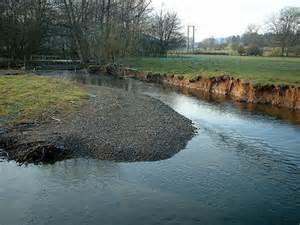
11th October: Revision questions:
What is the difference between the drainage basin system and the water cycle?
What are stores and transfers in the drainage basin? Give examples.
How do rivers transport their load?
How do meanders and oxbow lakes form?
We talked about the process of centrifugal force which forms river meanders and the ongoing process of oxbow lake formation - how we have tried to control it. We also looked at the cross section of a river meander using diagrams on p. 284
 A meandering river
6th October
Water cycle – closed system nothing leaves or escapes
Drainage basin – open system – outputs and inputs
River erosion, transportation and deposition (see p. 282 onwards)
The load is made up of boulders, rocks, pebbles, stones, sand, silt, clay, dissolved material.
It transports its load by 4 processes which are traction (rolling along), saltation (bouncing along), suspension (carrying along), solution (chemically within the water).
It erodes by the same processes as the sea (abrasion, hydraulic action, corrosion and attrition) but abrasion and attrition are more significant than hydraulic action.
When the current gets weaker in parts of a river, it deposits its load on the river bed and banks.
Why do rivers form meanders, cut offs and oxbow lakes?
Erosion happens on the outside of a bend because of centrifugal force and deposition on the inside because the current is slower, and both of these processes work together which makes the bend get bigger. This leads to the formation of meander loops and eventually to cut offs and oxbow lakes (we sketched a diagram on the board to illustrate this).
3rd October: We looked at drainage basins and the system and I gave your tests back. Next lesson I will go through the questions on the sheet and the answers to the test.
We will have a small test next lesson Thursday 29th about karst scenery and different types of weathering.

22nd September:
We talked about the rock cycle and drew a diagram on the board of it.
We then started to talk about a sedimentary rock, limestone, and the particular type of landforms associated with it, called Karst Scenery.
Homework : Read pages 248 to 249 about Karst Scenery.
We talked about the rock cycle and drew a diagram on the board of it.
We then started to talk about a sedimentary rock, limestone, and the particular type of landforms associated with it, called Karst Scenery.
Homework : Read pages 248 to 249 about Karst Scenery.
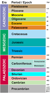
If you are interested, here is the mnemonic for the main geological ages: Camels often sit down carefully, perhaps their joints creak.
 Tree roots can split rocks apart - biological weathering
20th September:
We covered the differences between weathering and erosion, and the different ways in which weathering occurs, Physical and Chemical.
Homework : For Thursday’s lesson, complete the table with diagram/explanation for :
Physical – freeze/thaw, exfoliation, biological,
Chemical – carbonation.
Also read p. 247 about mass movement and landslides
 A beach with Groynes to prevent Longshore Drift in the Algarve, Portugal. Which way is the L.D. moving?
We talked about constructive and destructive waves and the differences between them, and then about depositional landforms formed by longshore drift (pps. 302 to 303 of the textbook). We took Spurn Head in Yorkshire as our example, and made a series of diagrams to explain its formation.
Homework for Tues 20th: Make two diagrams to show the formation of headlands and bays.
Also read the information and study the map and photographs of Spurn Head in Yorkshire and we will do these exercises in the next lesson.
Homework for Tues 20th: Make two diagrams to show the formation of headlands and bays.
Also read the information and study the map and photographs of Spurn Head in Yorkshire and we will do these exercises in the next lesson.

Tuesday 13th: We talked about the processes of erosion (corrosion, hydraulic action, abrasion and attrition), about how waves are formed, swash, backwash.
Homework for Thursday write a short explanation about the difference between constructive and destructive waves.
Biggest waves surfed: Portugal 2015 https://www.youtube.com/watch?v=OgDtRmSCxBg
These waves have an incredibly long fetch, across the Atlantic Ocean before they reach Portugal - it is the fetch and strength of winds which make the size of these big waves.
 Etretat Cliffs
Due next Tuesday – complete the series of 6 diagrams showing arch, stack and stump formation on the series of blank squares on the sheet I gave you.
- Formation of wave cut notch and wave cut platform.
- Formation of a cave.
- Cave enlarges to become an arch.
- Arch collapses to form a stack.
- Stack is eroded to become a stump.
- The whole sequence (as in the photo of Etretat).
The 4 units of work we are going to study this year are:
Dynamic Landscapes
Feeding the World
Urban Studies
Weather and Climate
see syllabus for more details (scroll down right to the bottom of this page)
Dynamic Landscapes
Feeding the World
Urban Studies
Weather and Climate
see syllabus for more details (scroll down right to the bottom of this page)
Welcome to year 5 ! Everything above this point is Year 5 work.

9th June: We revised 'Population Dynamics' using these revision questions.
Next lesson we will revise 'Threatened Environments: Problems and Solutions'
Next lesson we will revise 'Threatened Environments: Problems and Solutions'
6th June: Today we revised mapping skills and 'Structure of the Earth and Tectonics' Here are the revision questions
For Homework : Revision
Next lesson we will revise ‘population dynamics’
For Homework : Revision
Next lesson we will revise ‘population dynamics’
B Test on the whole year’s work
(but main focus on ‘Threatened Environments: Problems and Solutions)
16th June
Homework: Revise your notes for ‘The surrounding area/map skills’ and ‘Structure of the Earth and Tectonics’ for Monday 6th.
Also read and learn p. 131 about the effects of the Exxon Valdez Oil Spill on the environment.
Here are some links about the effects of the spill on the environment:
https://www.youtube.com/watch?v=CVm1pB3iJOw
https://www.youtube.com/watch?v=NLdH33JmscM
How to clean up oil spills: https://www.youtube.com/watch?v=3DbSlAg3F3A

30th May : We looked at:
Other types of energy:
Nuclear Power (p. 121)
Wind energy (p. 124)
Geothermal energy (p. 123)
Solar energy and other possible renewables (p. 125)
Other types of energy:
Nuclear Power (p. 121)
Wind energy (p. 124)
Geothermal energy (p. 123)
Solar energy and other possible renewables (p. 125)

The Three Gorges Dam
One of the responses to the threat from global warming is to invest in renewable forms of energy. One of these possibilities is to invest in huge HEP schemes like the one at Three Gorges in China. This now produces power for 60 million people and is 2km long and took 17 years to build. We are looking at the advantages and disadvantages of this scheme, using the video together with pages 294 to 295 of the text book.
Homework for next Monday : Write a side of A4 to summarise the advantages/disadvantages of the Three Gorges Dam (write a paragraph for each IN YOUR OWN WORDS). Finish with a short conclusion about whether you think the project is worth all the investment and time, in terms of its global, regional and local impact.
 Renewables
23rd May: We talked about solutions to global warming - reduce emissions of CO2 from burning fossil fuels and plant more trees and stop deforestation !
We discussed fossil fuels and where they come from (Oil, Coal and Gas) and why they are not renewable. Then we defined all the other types of renewable energy. We focussed on HEP (Hydro electric power) and read the page in the text book about it. We will continue with the '3 Gorges Dam' in China on Thursday and look at its adantages and disadantages.
We discussed fossil fuels and where they come from (Oil, Coal and Gas) and why they are not renewable. Then we defined all the other types of renewable energy. We focussed on HEP (Hydro electric power) and read the page in the text book about it. We will continue with the '3 Gorges Dam' in China on Thursday and look at its adantages and disadantages.
19th May: We put together all our stories to get a general view of what the most serious effects of global warming are.
For next lessons: Research and come to the lesson with your ideas about what the solutions are: What can we do to prevent global warming?
For next lessons: Research and come to the lesson with your ideas about what the solutions are: What can we do to prevent global warming?
 An emaciated polar bear on melting ice
Homework due for 19th May:
Effects of Global Warming
Using the diagram on p. 220 to help you, choose FIVE effects of global warming to focus on. For each one, write 100 words or so of details, IN YOUR OWN WORDS, having researched on the internet to find out your information. Write each one in the form of a table:
Effect:
Details:
Websites used:
For example:
Effect: Crops can be grown further north due to warmer weather.
Details: It is expected that we will see a general shift north of crops which thrive on warm temperatures. For example, the UK is already beginning to have olive farms and there are now British Vineyards producing wine. In Sussex, the temperature is on average a degree warmer than it was last century. Wine couldn't be grown before but now it can. An example is Rathfinny in Sussex which aims to produce over a million bottles of wine by 2020 to add to the overall British output which is already 5 million bottles. This may be good news for wine farmers, but it could be devastating for other types of crops which don’t enjoy warm temperatures.
Websites used: The guardian
 what could happen to an american city at some point in the future (according to 'The Nation'
9th May: We discussed the effects of global warming, including rising sea levels (from sea ice and land ice), changes in ecosystems, plants and animals, species changes, changes in precipitation patterns (flooding, desertification)
2nd May: Why is deforestation happening? We discussed the reasons, including plantations, farming, cattle, urbanisation, open cast mining, furniture, tourism, forest fires, etc. We also made a slight aside and talked about 'slash and burn' agriculture and native indigenous people.
25th April: We talked about a project we will do in a few weeks choosing anything you liked about the course of study and watched some youtube videos about relevant topics: Tsunami, antarctica/global warming/supervolcanoes

11th April: We talked again in much detail about the difference between the greenhouse effect (CO2) and the hole in the ozone layer. Quick test next lesson about this
Homework due next Thursday : Why are tropical rainforests being destroyed ?
Read p. 236 and research on the internet. Write at least 300 of YOUR OWN WORDS about the subject.
We talked about effects of deforestation and wrote notes on the following points:
Soil becomes infertile, fertilizers, eutrophication, etc.
Species extinction and its impacts.
Trees absorb CO2 and CO2 is the biggest factor in causing global warming.
We then made an aside describing the hole in the ozone layer and CFCs
There was some confusion between the hole in the ozone layer and global warming.
Here is the best answer (from yahoo)
Best Answer: Damage to the ozone layer and the greenhouse effect are both caused by different things, and have different results. The greenhouse effect is caused by a build up of gases (notably carbon dioxide and methane, among others) in the atmosphere that prevent heat radiating from the planet's surface out into space. This means that gradually more heat is retained by the atmosphere, leading to global warming. The ozone layer is damaged by gases such as Chloroflurocarbons (CFC's) which thins the ozone layer, or causes it to disappear completely in places (over the poles, generally). The ozone layer prevents harmful ultra violet light from penetrating the atmosphere, so without it exposure to the sun leads to an increased risk of skin cancer, sunburn, etc.
Hole in ozone layer - caused by CFCs from aerosols and fridges - causes skin cancer
Global warming - caused by increase in CO2 from burning fossil fuels (petrol, coal, etc.) - causes ice caps to melt and sea levels to rise, etc.
This video explains it - it's for kids but explains it clearly!
https://www.youtube.com/watch?v=-RMD88DNaGk
Here is a video that well describes global warming and the greenhouse effect.
https://www.youtube.com/watch?v=VYMjSule0Bw
https://www.youtube.com/watch?v=VYMjSule0Bw
 Plots are cleared by Amazonian Indians for planting crops
14th March: Using the nutrient cycle diagrams about an area which has rainforest and an area which had rainforest and has now been completely deforested, we talked about what happens to the soil when the rainforest is chopped down, and how these effects on soil fertility are very different from the slash and burn shifting cultivation employed by Amazonian Indians, for example. We said that the problem when the forest is cleared for palm oil plantations for example, is that a lot of fertilizer needs to be used to provide nutrients for the crops. This is because without the continuous input into the soil of the nutrients from the rich tropical rainforest vegetation, nutrients are leached (washed away by rainwater) very quickly, and you need an external source (fertilizers) to provide nutrients for the soil.
Here is some more information about shifting cultivation:
https://en.wikipedia.org/wiki/Shifting_cultivation
Question for homework for Thursday’s lesson (17th):
Why are fertilizers bad for the environment?
We will also talk about the other problems caused by deforestion, both local (eg. Soil erosion) and global.
Homework for Monday 14th – complete the sheets we did in the lesson about the tropical climate and rainforest and watch the videos I will put on the website: (the 3rd one is a bit long, watch some of it at least)
https://www.youtube.com/watch?v=beTLIa5EVe4
https://www.youtube.com/watch?v=wuHuQwA-y5Y
https://www.youtube.com/watch?v=ynUC_BqI90A
https://www.youtube.com/watch?v=beTLIa5EVe4
https://www.youtube.com/watch?v=wuHuQwA-y5Y
https://www.youtube.com/watch?v=ynUC_BqI90A
 Tropical Rainforest
7th March:
The next unit is ‘threatened environments : problems and solutions’ so we are going to look at a threatened environment, the tropical rainforest (p. 232 ), investigate its climate (p.212) , vegetation and biome (p.232), and then look at the threat of deforestation (p. 236), its effect on the world environment (p. 218) and then possible solutions (p.238) to it.
The Equatorial Climate
Read and become experts on p. 212 for next lesson (maybe a short test)
Thursday 3rd March. The next unit we are starting is 'Threatened Environments: problems and solutions'. We will be referring to world climates during this unit so today we did the pages in the book to revise the basics behind world climates (p. 210 to 211).
For homework next lesson, finish no. 2 parts a, b, and c on p. 227
For homework next lesson, finish no. 2 parts a, b, and c on p. 227
 Notting Hill Carnival, London
Geography S4 29/2/16 :
Read pages 24 and 25, about Migration into the U.K.
Write answers to all parts of question 2, p. 33 about these pages.
Read pages 24 and 25, about Migration into the U.K.
Write answers to all parts of question 2, p. 33 about these pages.
 the border fence between the USA and Mexico
Monday 22nd February: We looked at immigrants to California, taking the example from p. 30 to 31. We also talked about how NGOs can influence population change, reviewed rural urban and urban rural migration, commuting distance and how it is very important to compare examples of migration and look for similarities and differences.
B test next Thursday 25th
Population Dynamics
Rural Urban migration is …. (see p. 26)
Urban rural migration (counterurbanisation)
Homework read and revise p: 26 to 27 and revise all your notes for the Btest
Population Dynamics
Rural Urban migration is …. (see p. 26)
Urban rural migration (counterurbanisation)
Homework read and revise p: 26 to 27 and revise all your notes for the Btest

15th February:
Today, we watched the report about 'The Jungle' refugee settlement near Calais:
https://www.youtube.com/watch?v=z9khB8y-9Ms
- What is the current EU policy regarding asylum seekers and refugees ?
- What do you think is a good policy with regards to refusing entry/sending people back/welcoming?
Today, we watched the report about 'The Jungle' refugee settlement near Calais:
https://www.youtube.com/watch?v=z9khB8y-9Ms
Homework for Thursday 18th Feb.
Write a report about an example of migration, for example Poles to the UK, Syrian refugees to Europe, Mexicans to the USA, etc. For an example, look at pages 28 – 29.
Approximately 500 words
Include:
Reasons why they leave – forced/voluntary, push/pull factors
How they travel, make the journey
What happens when they arrive – effects on locals, are they successful, etc.
ALL IN YOUR OWN WORDS

China's One Child Policy
Homework for Thursday 4th Feb: After reading p. 13, and researching on the internet, complete the following sentences in your own words :
The one child policy was..
If you conformed (followed) it, then…
If you didn’t follow it, then…
You were excepted from the policy if…
The problems with the policy are…
The success of it is….
Here are some videos about the one child policy:
https://www.youtube.com/watch?v=l7FB6R3DtPM
https://www.youtube.com/watch?v=D0BPWFnL_jY

Read pages 8 to 9 about population pyramids, then do the exercises on p. 20, no 3 and 4 for next Monday 1st Feb. Also, read p. 14
Homework for Thursday 28th
Give 5 main reasons for high birth rates in stage 2
Give 5 main reasons why death rates start to fall in stage 2
Give 5 main reasons why birth rates fall in stage 3
What is stage 5? (find on p. 7). What are the problems for society in stage 5? (read p. 14 and give reasons.
REMEMBER ALL OF THE ABOVE! REVISE AND TEST EACH OTHER..
 Demographic transition, Births/deaths against time
Homework for Thursday 21st Jan.:
p. 19 Do exercise 1, parts a and b
Read pages 6 and 7 about the demographic transition model.
Do exercise 2 on p. 19.
p. 19 Do exercise 1, parts a and b
Read pages 6 and 7 about the demographic transition model.
Do exercise 2 on p. 19.
14th January. We discussed population density using the examples I gave you in the last lesson. 'We talked about concepts like relief, extreme climates, fertility of soil, rivers and water supply, trade, intensive agriculture, etc. Homework : Read p. 4 and 5 carefully about population density.
We talked about population density and the reasons for the following figures (in people per km2) :
Spain 93 Australia 3 China 145 The Netherlands 501 Greece 85 Shanghai 13,400 Mumbai 29,500
Brussels 2200
Homework for Thursday: Write a short summary (a few sentences) for each of these examples, explaining the factors why the population densities are dense or sparse. Think about both physical factors (climate, the relief) and human factors (trade, ports, types of housing). Think of reasons about how people live and why people live there.

7th January: POPULATION DYNAMICS
We looked at the world population graph and discussed the questions:
Describe the graph
Suggest reasons for the trends
How will it change in the future? We talked about reasons for birth rates, death rates and the population increase in history and how it will trend in the future.
We started with a definition of population density which we will continue with next lesson.

17th December: We watched half of the documentary about Pompeii and the eruption of Vesuvius in 79 AD, and saw some of the initial parts of the eruption; the pre-eruption quakes and swelling, the initial ash cloud up to 15 km high, pumice rain with volcanic bombs and how these ash and rock falls killed people and made roofs collapse.
 Escaping a pyroclastic flow
Holiday homework due for the first lesson after the holiday (11th January):
Write a report of a volcano (NOT MOUNT ST HELENS OR THE EXAMPLES FROM THE TEXT BOOK), at least 300 words, using the example on p. 268 to 269 as an example of the format to follow. USE YOUR OWN WORDS DON’T COPY AND PASTE TEXT Don’t forget to label and source images properly.
We watched parts of a documentary about Mount St. Helens and talked about its effects.
We also watched this about pyroclastic flows

10th December: Today we discussed the differences between predicting earthquakes and predicting volcanoes, and then started watching the documentary about the eruption of Mount Saint Helens, 1980.
3rd December: We looked at the two main types of volcano -
Cone - Destructive margins - explosive - grey - viscous - formed by melting plates
Shield - Constructive margins/hotspots - liquid - low angled slopes - formed from the upper mantle - black
And the main parts on the cross section of a volcano
We also briefly looked at Mount Merapi and its effects
Cone - Destructive margins - explosive - grey - viscous - formed by melting plates
Shield - Constructive margins/hotspots - liquid - low angled slopes - formed from the upper mantle - black
And the main parts on the cross section of a volcano
We also briefly looked at Mount Merapi and its effects
Monday 7th December : Geography B test – Structure of the Earth and Tectonics (see syllabus)
30th November:
We talked about tsunamis and how they are different to regular waves, what the different types are, and what the effects are, looking at this clip from the 2004 boxing day tsunami in Aceh, Indonesia.
https://www.youtube.com/watch?v=PQ0SFbiDrSk
We also discussed the Nepal earthquake, watching parts of the National Geographic documentary about it:
https://www.youtube.com/watch?v=mpMXEPN2EeA
Homework is to revise for the B Test
26th November: We talked about the effects of earthquakes, and the differences between LEDCs and MEDCs. We started talking about tsunamis, and will continue next lesson

Homework Assignment for 26th November :
Write a report about an earthquake that you choose. Include details of causes and effects like the one on p. 270 271 or 272 273
Include pictures and descriptions, approximately 250 words of writing. You can copy and paste pictures but do not copy and paste text. Do your research and then write it in your own words
16th October: We continued with the powerpoint from last lesson and explained the evidence for plate tectonics and more about plate margins, the ring of fire, etc.

Structure and History of the Earth and Plate Tectonics
We did the first 6 slides of the presentation
Here is a useful youtube video which explains well what we talked about:https://www.youtube.com/watch?v=_5q8hzF9VVE
We did the first 6 slides of the presentation
Here is a useful youtube video which explains well what we talked about:https://www.youtube.com/watch?v=_5q8hzF9VVE
9th November: Homework for Thursday, finish the sketch diagrams of 16.7, 16.8, 16.9 and 16.11.
We learnt about the different types of plate boundaries and where on the earth you will find each of them.
We learnt about the different types of plate boundaries and where on the earth you will find each of them.
A video about plate tectonics: https://www.youtube.com/watch?v=GeDcnFUvBdw

5th November: Today we introduced Plate Tectonics and made brief notes about the structure of the earth and the different types of crust and plate boundaries.
Homework Read pages 262 and 263 very carefully – ask questions next lesson if there is anything you don’t understand.
Homework Read pages 262 and 263 very carefully – ask questions next lesson if there is anything you don’t understand.
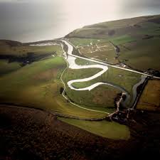 Cuckmere Haven, a meandering river mouth
Today we looked at a map of a coastal area 'Cuckmere Haven' in the South of England, and practised our mapping skills:
Grid references
Measuring distances
Compass Directions
Describing maps and doing sketches
Comparing maps and corresponding aerial photographs
Drawing a Cross Section
For today, do question 1 parts a to g and question 2 parts a, b and c
Here is the map and questions
Grid references
Measuring distances
Compass Directions
Describing maps and doing sketches
Comparing maps and corresponding aerial photographs
Drawing a Cross Section
For today, do question 1 parts a to g and question 2 parts a, b and c
Here is the map and questions
Homework for Thursday : Do no. 3 parts a and b of the Boscastle map (don’t do no. 4)
Note: The B test is next Monday 19th October
Latitude and Longitude
They are invisible lines which are able to show a global location. It is represented in degrees. The latitude 0 degrees is called the equator and the longitude zero degrees the Greenwich meridian. Longitude goes from North/South and Latitude goes from East to West. The equator is the middle of the Earth and the sun is always directly overhead at midday. The tropic of Cancer is at approx. 23 degrees North and Capricorn is 23 degrees South.
Choose 5 points on the map of Europe and give latitude/longitude for each one.
Familiarise yourself with the map of Europe for next lesson – countries, capitals, etc.
Homework for next Thursday 8th Oct : Draw a sketch map of the central area (use the area of the map I gave you) and annotate it with details of the main features and their significance. (annotate is different to labelling because it contains much written detail). Use the information which we discussed in today’s lesson for your annotations, and don’t make the actual sketch too complicated. I gave you 2 old maps of Brussels to help you in the task.
28th September: I gave you a map of the Brussels centre - homework for next lesson - write a summary of the main features of the map
Homework for Monday 28th:
Research and write what you can find out about:
The boulevard du triomphe and the area around the school.
The Ixelles ponds (place Flagey) and Bois de la Cambre.
Use a search engine (google), and I will put a couple of links on the website:
wikipedia of course, and:
http://laplaine.jimdo.com/pr%C3%A9sentation/historique-du-site/
Research and then write out in your own words (copy and paste will be considered work not done)

21st September: Contour lines are brown lines on a map which join places of equal height. They are marked in metres and using these we can see the relief (the shape of the land), hills, mountains, valleys, slopes.
If the contours are close together, then the land is steep, if they are far apart, then the land is gentle and if there are no contours, then the land is flat. Usually the contour interval is 10m or 5m. If the contours are in a ring shape then there is a hill or mountain.
The Tring map is 1:25 000 this means that it is 25 000 times smaller than reality.
1:10 000 would show an area in more/ detail.
1:100 000 would show an area in/less detail.
I gave you the map of our area and you are making 5 grid references for points on the map.
17th Sept: For: The garden centre at 932133 and Marshcroft cottages at 938128 on the Tring map
Distance as the crow flies
Compass direction
Route you would have to take if you were going there
Distance you would have to walk/drive if you were going from one to the other.
Homework for Monday: Complete this question and:
Write a description (in about 100 words) of the main features of this map.
Next lesson we will practice these more, and look at scale and the map of our area.

14th Sept: We looked at compass directions and 6 figure grid references. Homework for next lesson Thursday 17th
Study the map of Tring and make 5 questions for the class about compass directions/6 figure grid references
Study the map of Tring and make 5 questions for the class about compass directions/6 figure grid references

10th Sept : We watched a video from the ‘People’s Century’ series www.internationalschoolhistory.com about people realizing how pollution produced in one place can affect other places (or even the whole planet). Some of the events which occurred to make people realize this were:
Minimata mercury poisoning, Japan. Mercury entered the food chain.
First Oil Spill, Torrey Canyon, Scotland.
Use of pesticides, DDT to kill insects on food crops entered the sea and made the egg shells of the fish eating pelicans very weak and so the pelicans couldn’t breed.
These types of realisations led to a worldwide movement to protest against pollution, culminating in Earth day in 1970.

Geography we talked about the syllabus, the content and skills
We looked at 4 figure and 6 figure grid references, and will review them next lesson and practice them more.
I gave you the sheets with the key for 1:25 000 maps, a 1:25 000 map of Bradley farm, and an A3 sheet describing mapping skills
We looked at 4 figure and 6 figure grid references, and will review them next lesson and practice them more.
I gave you the sheets with the key for 1:25 000 maps, a 1:25 000 map of Bradley farm, and an A3 sheet describing mapping skills
